Tulum Ruins Map and Site Layout
The walled area at Tulum is about 400 metres long and 170 deep — small enough to walk in ninety minutes, and laid out so that the route takes you round it in one direction. This is what sits where, in the order the site sends you.
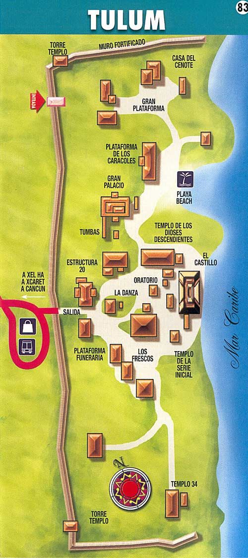
The route as the site sends you round it
- In through the wall. You enter through one of the narrow gateways on the landward side. The gateway is the first thing worth looking at — see how little of it there is.
- The Temple of the Frescoes, on your left. Most people walk past it toward the sea. Do not.
- El Castillo, on the cliff. The high point of the circuit in both senses.
- The Temple of the Descending God, just north of it. Small, and the carving is above the door.
- North along the cliff. This is where the photograph is, looking back.
- The residential buildings, and out. The House of the Columns and the House of the Halach Uinic on the way to the exit.
El Castillo
The building everyone photographs, and the reason the postcards look the way they do. It is not a tall stepped pyramid — it is a broad, low platform right on the cliff edge, with a wide central staircase and a squat temple on top whose doorway is divided by two columns. It stands about 7.5 metres above the platform, and the platform stands on a 12-metre limestone cliff, which is what does the work in a photograph. It faces the sea, and the two small windows in its upper chamber line up with the gap in the reef.
Temple of the Frescoes
The most informative building on the site and the one most people walk past. Its inner chamber carries the best-surviving painted murals at Tulum — blue-green figures on a dark ground — and its outer facade still holds stucco reliefs, including seated figures and a mask at each corner of the lower storey. It was built in stages, and you can read the stages in the masonry.
Temple of the Descending God
A small building on the north side of El Castillo, named for the figure above its doorway: an upside-down human form, head down and legs up, arms held to the sides, as though diving. The same figure appears elsewhere on the site. Nobody can tell you with certainty who he is — the honest readings run from the setting sun to the bee god to Venus — and the guides who say otherwise are guessing.
House of the Halach Uinic
Named for the title of a Maya ruler — roughly “the real man”, the highest office in a Maya polity. A large structure with a colonnaded front, decorated with more descending figures. Whether a ruler actually lived here is inference from the building's size and position rather than anything written down.
House of the Columns
One of the larger residential buildings in the walled area, with the row of columns that gives it its name. Tulum's elite lived inside the wall; most of the population lived outside it, in buildings that have not survived.
The wall
The thing the site is named after. A wall runs along three landward sides — roughly 400 metres by 170 — three to five metres thick and three to five metres high, with narrow gateways and watch positions at the corners. The fourth side is the cliff, which needed no wall.
The beach stair, and when it is closed
A wooden stair drops from the platform to the small cove below El Castillo. It is one of the reasons Tulum photographs the way it does. It is also closed more often than visitors expect. Sea conditions close it. So does turtle nesting, between roughly May and October. Treat it as a bonus rather than a plan.
How the site fits together
Three bands, running parallel to the sea. The wall and its gateways form the landward edge. Inside that sits the residential band — the House of the Columns, the House of the Halach Uinic, and the smaller structures around them. Then comes the ceremonial edge on the cliff itself, where El Castillo and the two named temples stand.
That layout is the site's argument in miniature. The buildings that mattered face the water. The ones people lived in sit behind. The wall keeps the landward side out.
How long each part takes
| Part of the site | Allow | Why |
|---|---|---|
| Wall and gateway | 10 min | Worth a proper look. Most people walk straight through. |
| Temple of the Frescoes | 10 min | The murals need low light, so go early. |
| El Castillo and the cliff | 20 min | The photograph is from the north, looking back. |
| Temple of the Descending God | 5 min | Small. Look above the doorway. |
| Residential buildings | 15 min | Where the site stops being temples. |
| Walk in and out | 40 min | From the car park, both ways. Underestimated. |
Toilets, water and shade
Facilities are in the entrance area, before you pass into the archaeological zone. There are none inside the walls. Go before you go in. There is no shop either, and no useful shade — the visiting page sets out what to carry.